


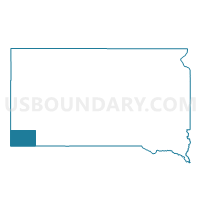
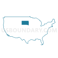
VTD - Smithwick voting district, Fall River County, South Dakota
About
Outline

Summary
| Unique Area Identifier | 667283 |
| Name | VTD - Smithwick voting district |
| County | Fall River County |
| State | South Dakota |
| Area (square miles) | 200.06 |
| Land Area (square miles) | 199.96 |
| Water Area (square miles) | 0.11 |
| % of Land Area | 99.95 |
| % of Water Area | 0.05 |
| Latitude of the Internal Point | 43.29659610 |
| Longtitude of the Internal Point | -103.14067090 |
Maps

Graphs
Select a template below for downloading or customizing gragh for VTD - Smithwick voting district, Fall River County, South Dakota


Neighbors
Neighoring Voting District (by Name) Neighboring Voting District on the Map
- VTD - Beaver voting district, Fall River County, SD
- VTD precinct - Limestone, Fall River County, SD
- VTD- precinct Jackson, Fall River County, SD
- VTD-precinct CunyTable, Shannon County, SD
- VTD-precinct Oglala, Shannon County, SD
Top 10 Neighboring County Subdivision (by Population) Neighboring County Subdivision on the Map
- West Shannon UT, Shannon County, SD (8,153)
- Northeast Fall River UT, Fall River County, SD (2,095)
- Robins township, Fall River County, SD (29)
Top 10 Neighboring Unified School District (by Population) Neighboring Unified School District on the Map
- Shannon County School District 65-1, SD (13,586)
- Hot Springs School District 23-2, SD (5,954)
- Oelrichs School District 23-3, SD (355)